ABOUT GUATEMALA

Guatemala is a country in Central America, in the south part of North America, bordering Mexico to the northwest, the Pacific Ocean to the southwest, Belize and the Caribbean Sea to the northeast, and Honduras and El Salvador to the southeast.
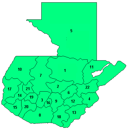
Guatemala is divided into 22 departments (departamentos) and sub-divided into about 332 municipalities (municipios). The departments include:
- Alta Verapaz
- Baja Verapaz
- Chimaltenango
- Chiquimula

- Petén
- El Progreso
- El Quiché
- Escuintla
- Guatemala
- Huehuetenango
- Izabal
- Jalapa
- Jutiapa
- Quetzaltenango
- Retalhuleu
- Sacatepéquez
- San Marcos
- Santa Rosa
- Sololá
- Suchitepéquez
- Totonicapán
- Zacapa
See on "GUATEMALAN PHOTOS" for some pictures of each departament.
Politics of Guatemala takes place in a framework of a presidential representative democratic republic, whereby the President of Guatemala is both head of state and head of government, and of a pluriform multi-party system. Executive power is exercised by the government. Legislative power is vested in both the government and the Congress of the Republic. The Judiciary is independent of the executive and the legislature.
GENERAL INFORMATION
National name: República de Guatemala
Land area: 41,865 sq mi (108,430 sq km);
Total area: 42,042 sq mi (108,890 sq km)
Population (2006 est.): 12,293,545 (growth rate: 2.3%); birth rate: 29.9/1000; infant mortality rate: 30.9/1000; life expectancy: 69.4; density per sq mi: 294
Capital and largest city (2003 est.): Guatemala City, 2,655,900 (metro. area), 1,128,800 (city proper)
Other large cities: Mixco, 287,600; Villa Nueva, 138,900
Monetary unit: Quetzal
Languages: Spanish 60%, Amerindian languages 40% (23 officially recognized Amerindian languages, including Quiche, Cakchiquel, Kekchi, Mam, Garifuna, and Xinca)
Ethnicity/race: Mestizo (Ladino)—mixed Amerindian-Spanish ancestry—and European 59.4%, K'iche 9.1%, Kaqchikel 8.4%, Mam 7.9%, Q'eqchi 6.3%, other Mayan 8.6%, indigenous non-Mayan 0.2%, other 0.1% (2001)
Religions: Roman Catholic, Protestant, indigenous Mayan beliefs
Literacy rate: 71% (2003 est.)
Economic summary: GDP/PPP (2005 est.): $62.97 billion; per capita $5,200. Real growth rate: 3.1%. Inflation: 9.1%. Unemployment: 7.5% (2003 est.). Arable land: 13%. Agriculture: sugarcane, corn, bananas, coffee, beans, cardamom; cattle, sheep, pigs, chickens. Labor force: 3.76 million; agriculture 50%, industry 15%, services 35% (1999 est.). Industries: sugar, textiles and clothing, furniture, chemicals, petroleum, metals, rubber, tourism. Natural resources: petroleum, nickel, rare woods, fish, chicle, hydropower. Exports: $3.94 billion f.o.b. (2005 est.): coffee, sugar, petroleum, apparel, bananas, fruits and vegetables, cardamom. Imports: $7.744 billion f.o.b. (2005 est.): fuels, machinery and transport equipment, construction materials, grain, fertilizers, electricity. Major trading partners: U.S., El Salvador, Honduras, Mexico, South Korea, China, Japan (2004).
Communications: Telephones: main lines in use: 846,000 (2002); mobile cellular: 1,577,100 (2002). Radio broadcast stations: AM 130, FM 487, shortwave 15 (2000). Television broadcast stations: 26 (plus 27 repeaters) (1997). Internet hosts: 20,360 (2003). Internet users: 400,000 (2002).
Transportation: Railways: total: 886 km (2004). Highways: total: 14,118 km; paved: 4,871 km (including 74 km of expressways); unpaved: 9,247 km (1999). Waterways: 990 km; note: 260 km navigable year round; additional 730 km navigable during high-water season (2004). Ports and harbors: Puerto Quetzal, Santo Tomas de Castilla. Airports: 452 (2004 est.).
International disputes: Guatemalan squatters continue to settle in the rain forests of Belize's border region; OAS is attempting to revive the 2002 failed Differendum that created a small adjustment to land boundary, a Guatemalan maritime corridor in Caribbean, a joint ecological park for the disputed Sapodilla Cays, and a substantial US-UK financial package; Guatemalans enter Mexico illegally seeking work or transit to the US.
posted by Mauricio Cabarrús @ 8:18 PM
![]()


0 Comments:
Post a Comment
<< Home